| [ Web Proxy ] |
| Viewing: https://www.dailystar.co.uk/news/latest-news/fifth-heatwave-uk-weather-maps-37519381 | [Back] [Original] |
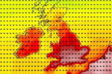
Weather maps show Britain is set to bake(Image: Netweather)
The UK is braced for yet another scorching heatwave as blistering 37C temperatures are predicted for next week.
Netweather maps reveal that the mercury will begin to soar on Sunday, climbing beyond 30C across much of the country, with the sweltering conditions expected to persist for at least six days.
This marks the fifth official heatwave Britain has endured this season. Come Sunday, temperatures will hit 34C with the most intense heat concentrated in the south, where temperatures will sit comfortably at 32C or above.
Meanwhile, highs exceeding 30C are also anticipated elsewhere, reports the Express. Across the East and West Midlands, peaks of 32C are similarly predicted throughout the day.
Brits will be back to the beaches again this school holiday (Image: Gareth Fuller/PA Wire)
Although it will be slightly more bearable in northern England, Greater Manchester is still set to experience 29C.
These blazing conditions will persist into the following week, with Monday marking when the heat reaches its peak.
High temperatures of 37C are predicted in Berkshire, approaching the recent record 38C that was logged at Lingwood, Norfolk on June 26.
London, together with Cambridgeshire and select areas of the south west, will climb to 35C while neighbouring Hertfordshire is anticipated to reach 36C.
However, the soaring temperatures won't end there, as Tuesday will bring additional hot spells, with the warm air advancing northwards.
Numerous regions across the Midlands and the south will easily remain in the mid-thirties while Greater Manchester and Cheshire are also projected to hit 34C and 35C.
It comes as parts of the south are on verge of a drought(Image: Getty Images)
The weather charts remain a fiery red into Wednesday, as parts of Yorkshire also reach 30C. Despite the cooler conditions, on this day parts of Wales and Scotland are also expected to reach the mid twenties.
The scorching weather will then persist until Thursday, as highs of 35C are forecast with London remaining at 34C.
Then on Friday additional areas are set to experience 35C according to the weather maps, with Sussex and Norfolk enjoying the sweltering conditions.
In Lincolnshire there are also anticipated to be highs of 33C, with Birmingham hitting 32C.
The Met Office states: "A heatwave is an extended period of hot weather relative to the expected conditions of the area at that time of year, which may be accompanied by high humidity."
The UK's threshold is achieved when a section of the country records a period of at least three consecutive days with daily maximum temperatures meeting or exceeding the heatwave temperature threshold - which varies by county.
Under this definition the six day stretch of heat means the UK will experience its fifth official heatwave of the year, as droughts continue to cause problems across the nation.
The Met Office forecast states that it will be dry for most on Monday with temperatures on the very warm to hot side.
The longer range forecast then continues adding: "For the most part, temperatures look to remain above average, especially in the south, and perhaps turning very warm or hot."
For the latest breaking news and stories from across the globe from the Daily Star, sign up for our newsletters.
Choose Daily Star as a 'Preferred Source' on Google News for quick access to the news you value.
 [Google Preferred Source Badge]
At Reach and across our entities we and our partners use information collected through cookies and other identifiers from your device to improve experience on our site, analyse how it is used and to show personalised advertising. You can opt out of the sale or sharing of your data, at any time clicking the "Do Not Sell or Share my Data" button at the bottom of the webpage. Please note that your preferences are browser specific. Use of our website and any of our services represents your acceptance of the use of cookies and consent to the practices described in our Privacy Notice and Terms and Conditions.
Accept| Web Proxy Viewer | New URL | Original Page |




![[Daily Star]](https://www.dailystar.co.uk/nav-web-static/main-1203a175ed6ce47e924c82721a3f0ba020eab5f8/public/assets/dailystar/logos/masthead-dailystar-default.svg)
![[Dailystar Icon]](https://www.dailystar.co.uk/assets/icons/daily-star.svg)
![[Weather map]](https://i2-prod.dailystar.co.uk/article37519380.ece/ALTERNATES/s1200f/0_Weather-map.jpg)
![[People enjoy the warm weather on the beach in Folkestone, Kent. ]](https://i2-prod.dailystar.co.uk/article37519398.ece/ALTERNATES/s1200e/0_Summer-weather-Aug-4th-2026.jpg)
![[Dry field in the south of the England ]](https://i2-prod.dailystar.co.uk/article37519407.ece/ALTERNATES/s1200e/2_Drought-Declared-Across-Parts-of-England.jpg)
![[Google Preferred Source Badge]](https://www.dailystar.co.uk/_next/image?url=%2Fgoogle-preferred-source-badge-dark.png&w=640&q=75)
![[Ipso logo]](https://www.dailystar.co.uk/footer/ipso.svg)
![[trust project logo]](https://www.dailystar.co.uk/footer/trust-project.svg)
![[reach logo]](https://www.dailystar.co.uk/_next/image?url=%2Fnav-web-static%2Fmain-1203a175ed6ce47e924c82721a3f0ba020eab5f8%2F_next%2Fstatic%2Fmedia%2Flogo-reach.18f672b1.png&w=384&q=75)